 Polish Polar DataBase
University of Silesia
Type of resources
Available actions
Topics
Keywords
Contact for the resource
Provided by
Years
Representation types
Update frequencies
status
Scale
-
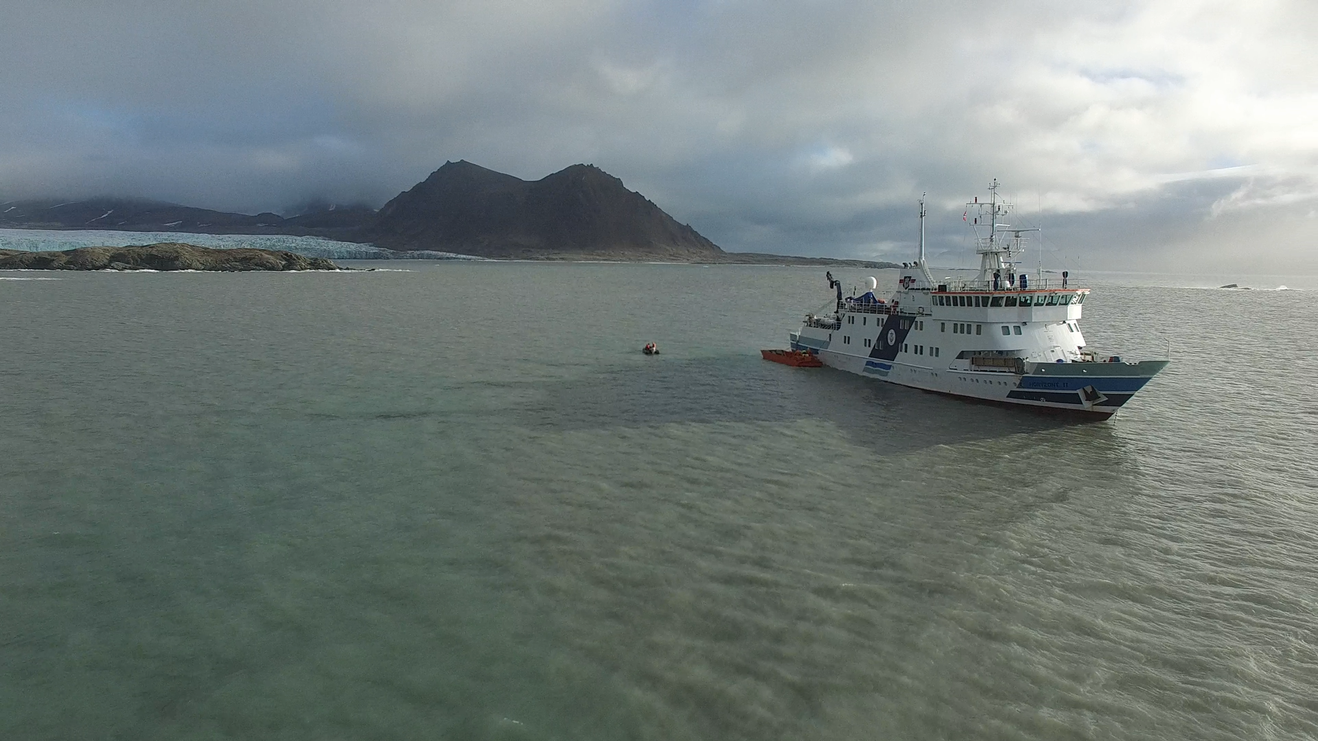
1. Two high-quality UAV movies taken in Hornsund fiord on 15th Sep 2016 with Phantom 3 Advanced usage. The movies are focused on Horyzont II ship during unloading goods to the Polish Polar Station Hornsund. Format file: .MOV. 2. Dataset consist six UAV movies taken in neighborhood of stake no. 4 of Hansbreen, one taken in the vicinty of stake no. 6 of Hansbreen and two on Tuvbreen. The movies from stake no. 4 show the ablation zone, crevasses, glaciers in the area and a team of University of Silesia scientists during maintanance of automatic weather station (AWS). The movie from stake no. 6 presents the surface of Hansbreen towards accumulation zone. The movies from Tuvbreen show the area around, surface of the glacier and University of Silesia team. UAV: Phantom 3 Advanced. Format file: .MOV. 3. One high-quality UAV movie taken from West morain of Paierbreen 22nd Aug 2016 with Phantom 3 Advanced usage. The movie is focused on the front of Paierlbreen. Format file: .MOV. 4. Two high-quality UAV movies taken on Silesiabreen 23nd Aug 2016 with Phantom 3 Advanced usage. The movie is focused on the snowline of Silesiabreen, University of Silesia scietists while fieldwork and neighbourhood. 5. UAV movie of Storbreen upper ablation area in 21st Aug 2016. 6. Three high-quality UAV movies taken from vicinity of Treskelen in Hornsund on 12 Sep 2016 with Phantom 3 Advanced usage. The movies are focused on the University of Silesia team during automatic weather station maintanance, sailing boat operated by scientists and Hornsund fiord. 7. A high-quality UAV movie taken from vicinity of Brateggbreen on 5 Sep 2016 with Phantom 3 Advanced usage. The movie is focused on Brateggbreen front and its proglacial lake. Format file: .MOV. 8. UAV movies of Werenskoildbreen front and morain in summer 2016
-
The orthophotomap was prepared on the basis of infrared aerial photographs taken by EUROSENSE in September 1998. The study covers the Dolina Kiezmarskej Bieley vody valley located in the High Tatra Mountains (Slovakia). Cartographic projection: Universal Transverse Mercator, Ellipsoid: WGS 84, Coordinates system: UTM zone 34. The project was financed by No.3P04E 045 23. Editors: Bogdan Gądek, Milan Koren (sen.), Milan Koren (jun.) The project was financed by the Polish Commitee on Scientific Research under term of research grant No. 3P04E 045 23.
-
1. Dataset of UAV vertical aerial photos of Calypsobyen obtained from height of: 100m (58 photos), 60m (45 photos) and 30m (59 photos). Used UAV: Phantom 3 Advanced, date of acqusition: 16 Aug 2016. 2. Dataset of UAV vertical aerial photos of Paierlbreen east morain/dead ice obtained from height of 50m (152 photos). Area covered: ~250x~130m (with gaps).Used UAV: Phantom 3 Advanced, date of acqusition: 22 Aug 2016. 3. Dataset of UAV vertical aerial photos of Storbreen, close to Komsa (52 photos). Area covered: ~350x~230m. Used UAV: Phantom 3 Advanced, date of acqusition: 21 Aug 2016. 4. Dataset of UAV vertical aerial photos of Werenskoildbreen's south moraine (300 photos). Area covered: ~200x~350m and ~250x~250m. Used UAV: Phantom 3 Advanced, date of acqusition: 7 Sep 2016.
-
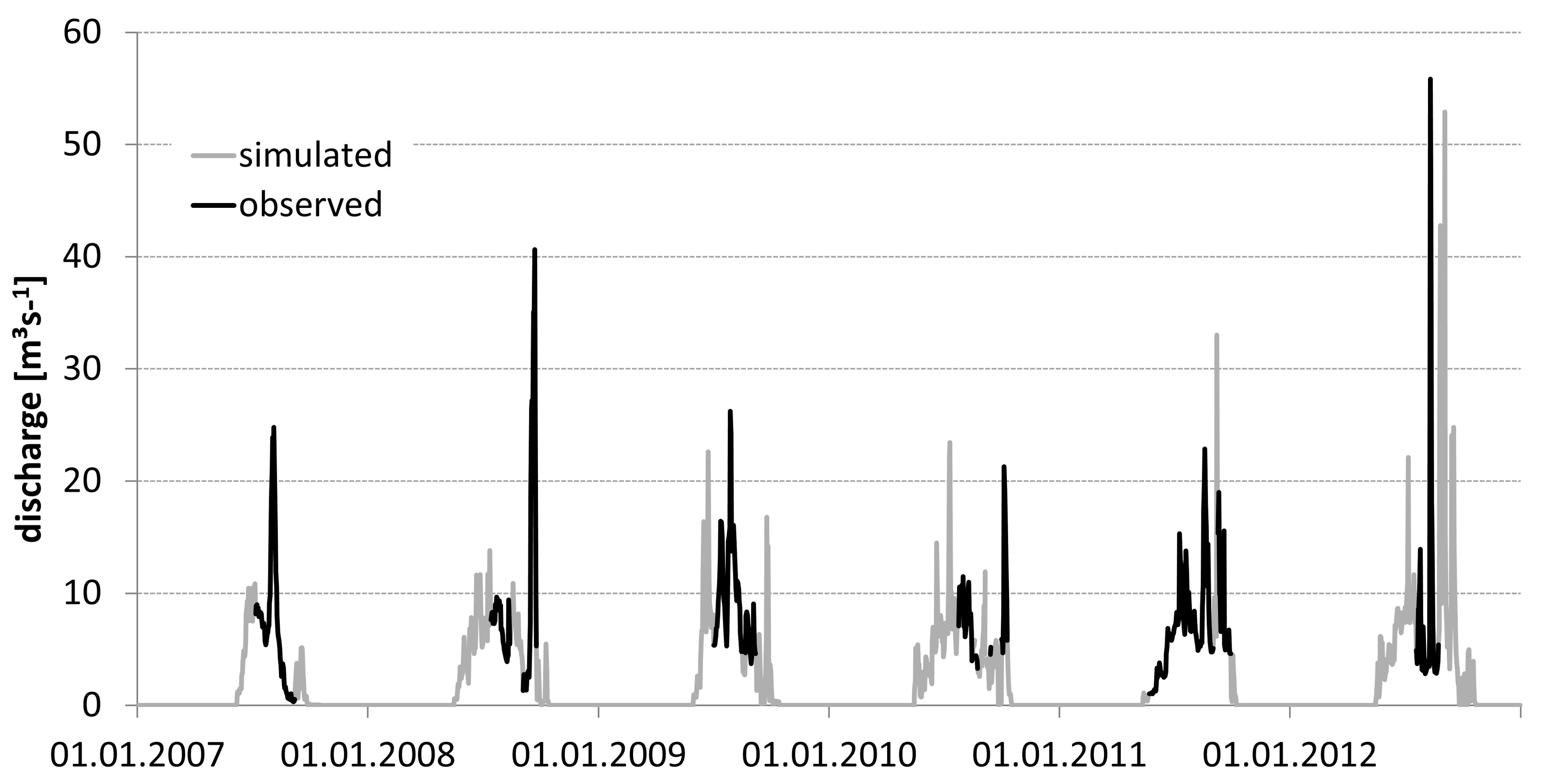
• Discharge measurements were conducted from May/June/July to September/October in the years 2007–2012. Direct observation periods were 62, 51, 61, 40, 121, and 35 days in the consecutive years. The data set was obtained from CTD-DIVER DI 261 or Mini-Diver (Van Essen Instruments, Delft, The Netherlands) logger with barometric compensation by BaroDiver (Schlumberger, Houston, TX, USA) with 10-min intervals and flow velocities were measured with a SEBA F1 current meter (SEBA Hydrometrie GmbH, Kaufbeuren, Germany). Mean daily discharge and total runoff in the hydrologically active season was calculated on the basis of the 24h running average of the water level and a rating curve (Appendix 1). More details have been reported by Majchrowska E., Ignatiuk D., Jania J., Marszałek H., Wąsik M., 2015: Seasonal and interannual variability in runoff from the Werenskioldbreen catchment, Spitsbergen. Polish Polar Research vol. 36, no. 3, pp. 197–224. doi: 10.1515/popore−2015−0014 • Hydrological data for Werenskioldbreen - archive of the University of Silesia. The base contain mean daily discharge in the years: 1970, 1971, 1972, 1973, 1974, 1979, 1980, 1983, 1985, 1986, 1988, 1998, 2007, 2008, 2009, 2010, 2011, 2012, 2013, 2017, 2019 (21 hydrologically active seasons) – Appendix 2
-
The bathymetry data for Hansbukta includes depth measurements from different sources: data collected in 2014, 2016 and 2017 from a small boat using a Norbit Wideband Multibeam Sonar with positioning system, measurements collected in 2015 from a small boat using single beam echosounder Lowrance HDS5 with positioning and data from the Norwegian Hydrographic Service collected using a multi-beam survey in 2007–2008. Accuracy of the bathymetry from these different sources is assessed as ±5 m. The database is the supplement to the paper: Małgorzata Błaszczyk, Jacek A. Jania, Michał Ciepły, Mariusz Grabiec, Dariusz Ignatiuk, Leszek Kolondra, Aleksandra Kruss, Bartłomiej Luks, Mateusz Moskalik, Tadeusz Pastusiak, Agnieszka Strzelewicz, Waldemar Walczowski, Tomasz Wawrzyniak. “Factors controlling terminus position of Hansbreen, a tidewater glacier in Svalbard”, Journal of Geophysical Research - Earth Surface, https://doi.org/10.1029/2020JF005763.
-
High resolution orthophoto images from Geoeye, WorldView-2 and Pléaides processed in OrthoEngine module of PCI Geomatica. Data format: grid, UTM 33X / EGM 2008. Spatial resolution: 0.5 m (panchromatic and pansharpened) and 2 m (multispectral).
-
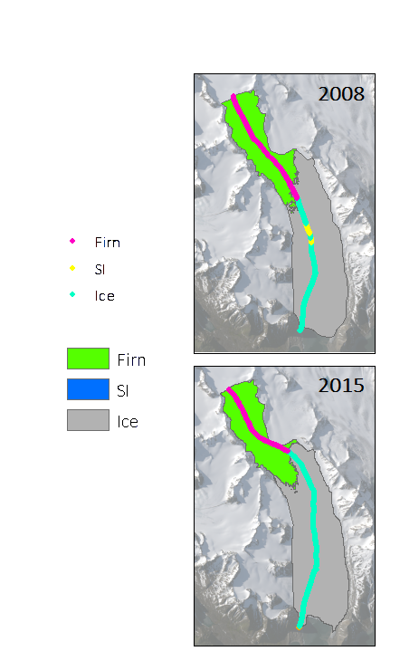
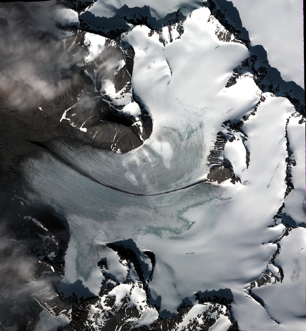
Glaciers facies (ice, superimposed ice, firn) extents of Hansbreen, Storbreen and Flatbreen delivered from unsupervised classifications of single, dual and fully-polarimetric SAR data (ALOS-2 PALSAR, RADARSAT-2, Sentinel-1, ERS-2 SAR) between 2008 and 2018. Methods of classification: unsupervised ISO classification, H-a Wishart Classification. Results validated with terrestrial measurements (shallow ice cores drilling, Ground Penetrating Radar measurements). Research supported by the European Space Agency, Third Party Missions grant and Svalbard Science Forum, Arctic Field Grant 2018. For more details, please e-mail to bbarzycka@us.edu.pl.
-
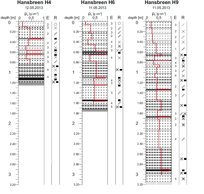
Dataset contains detailed measurements of physical features of seasonal snow cover, according to International Classification of Seasonal Snow on the Ground (Fierz et al. 2009). Fieldwork has been done during peak of accumulation on several glaciers in the region of Hornsund, Svalbard: Amundsenisen (2013) Hansbreen (three sites; 2010, 2012, 2013, 2014, 2015, 2017, 2018) Werenskioldbreen (two sites; 2013, 2015) Nannbreen (2013) Ariebreen (2014) Acknowledgements: Research Council of Norway, Arctic Field Grant 2013: Spatial distribution of snow cover and drainage systems on the glaciers on Wedel Jarlsberg Land (RiS ID: 6158); the National Science Centre PRELUDIUM 4: Role of meltwater from snow cover for supplying drainage systems of the Spitsbergen glaciers (2012/07/N/ST10/03784) References: Laska M., Luks B., Budzik T., 2016. Influence of snowpack internal structure on snow metamorphism and melting intensity on Hansbreen, Svalbard. Polish Polar Research, 37(2): 193–218. doi:10.1515/popore-2016-0012 Laska M., Grabiec M., Ignatiuk D., Budzik T., 2017. Snow deposition patterns on southern Spitsbergen glaciers, Svalbard, in relation to recent meteorological conditions and local topography. Geografiska Annaler, Series A: Physical Geography, 99(3): 262–287 doi:10.1080/04353676.2017.1327321 Laska M., Barzycka B., Luks B., 2017. Melting Characteristics of Snow Cover on Tidewater Glaciers in Hornsund Fjord, Svalbard. Water, 9(10), 804. doi:10.3390/w9100804
-
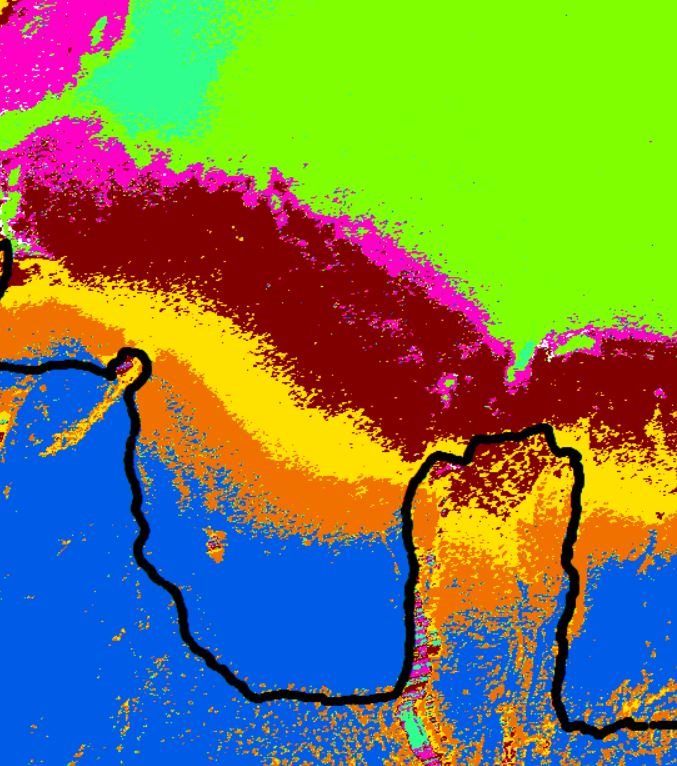
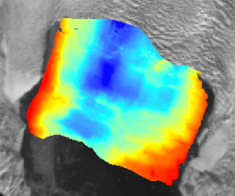
Glaciers facies extents of Langjökull delivered from unsupervised classifications of fully-polarimetric SAR data (ALOS-2 PALSAR, RADARSAT-2) for 2018 year. Date of SAR images acquisitions: 12, 16 Mar 2018 (Fine Quad Pol RADARSAT-2), 17 Mar 2018 (High Sensitive Quad Pol ALOS-2 PALSAR). Method of classification: H-a Wishart Classification. Results validated with terrestrial measurements (shallow ice cores drilling, Ground Penetrating Radar measurements). Research done with cooperation with University of Iceland and supported by the European Space Agency, Third Party Miassions. Overwiew of results of RADATSAT-2 (16 Mar 2018; Fine Quad Pol) classification of south part of Langjökull. Black line - contour of Langjökull; other colours - different scattering properties of SAR microwaves. For more details please contact Barbara Barzycka (bbarzycka@us.edu.pl).
-
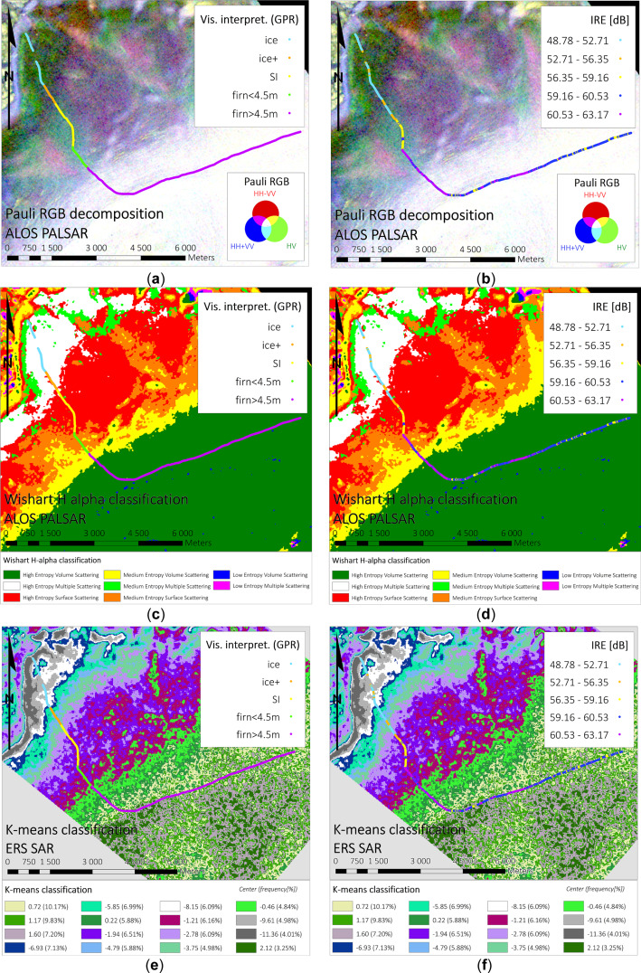
Glaciers facies extents of Vestfonna delivered from unsupervised classifications of SAR data (fully-polarimetric ALOS PALSAR, single polarimetric ERS-2 SAR) for 2009 year. Date of SAR images acquisitions: 4, 7, 20, 23, 26 May 2009 (VV Single Look Complex ERS-2 SAR), 22 May 2009 (ALOS PALSAR Single Look Complex 1.1, quad polarimetry). Method of classification: K-means classification, H-a Wishart Classification. Results validated with Ground Penetrating Radar data. For more information, please check: https://doi.org/10.1016/j.rse.2018.11.020 Overwiew of results of different classification methods with comparison to GPR data. Top panel: Pauli decomposition, middle panel: H-a Wishart classification, bottom panel: k-means classification. For more information, please check: https://doi.org/10.1016/j.rse.2018.11.020 (Figure 7).